
Sada Al-Waqi’ – Yemen Exclusive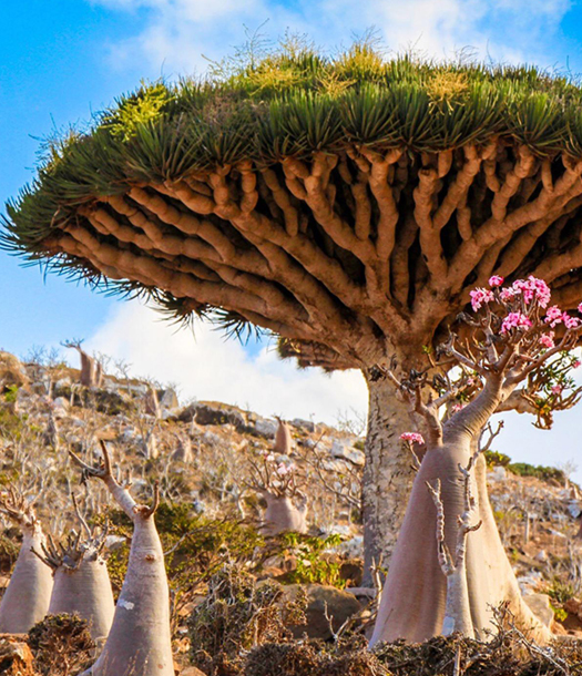
Socotra Island, the largest of Yemen’s islands, has long stood as a natural and historical gem. Administratively affiliated with Hadramout Governorate under Republican Law No. (23) of 1999, it was officially declared a natural protected area in 2000. Historically, the island was once administered by the Governorate of Aden.
A Legacy of Sacred Trade and Global Fascination
Dating back to the first millennium BCE, Socotra was globally renowned as a key center for producing sacred goods such as incense and myrrh—materials widely used in ancient religious rituals. This lent the island a sanctified status in the eyes of ancient civilizations. In antiquity, Socotra was linked to the Kingdom of Hadramout, while in more recent history, it fell under the rule of the Mahra Sultanate until the Yemeni Revolution.
Throughout history, Socotra captured the imaginations of travelers and geographers. Its wealth in precious resins and marine treasures placed it in the sights of explorers and empires. The Portuguese occupied the island in 1507, and the British later seized it, turning it into a strategic rear base to support their 1839 occupation of Aden.
Rediscovery After Unity
After years of isolation and neglect, Socotra began to reclaim its historic and strategic relevance following Yemen’s unification in 1990. Its proximity to the Horn of Africa and location at the mouth of the Gulf of Aden made it a crucial link in international maritime navigation, particularly in the western Indian Ocean. Its exceptional biodiversity and natural riches also contributed to its growing recognition as one of the world’s key ecological hotspots.
Geography and Location
Socotra lies off the southern coast of Yemen, near the city of Mukalla, between latitudes 12.18° and 12.24°N and longitudes 53.19° and 54.33°E. It is located about 380 km from Ras Fartak in Al-Mahra Governorate and approximately 553 miles from the city of Aden. Its proximity to the equator contributes to its tropical climate and rich vegetation.
Area: The island spans 3,650 km².
Shape: A mix of rectangular and fragmented landforms.
Archipelago: Includes smaller islands surrounding the main island.
Terrain and Topography
Socotra shares a similar geological base with the Arabian Peninsula, composed of ancient igneous and metamorphic rocks, including abundant granite. The island’s terrain features a mix of mountains, plateaus, valleys, and coastal plains:
Central Plateau: Occupies most of the island, split into eastern and western sections by Wadi De-Azro.
Northern Coastal Plains: Including Hadibo Plain and areas such as Ras Midhhan and Wadi Draba’a.
Southern Plains: Known as the Noged Plain, these include Wadi Difarho and Wadi Di-Azroho, stretching from Ras Momi in the east to Ras Shuab in the west. These areas have fertile soils suitable for agriculture, particularly where sand dunes line the coast.
Mountain Ranges
Hagghier Mountains: The island’s highest peak reaches 1,500 meters in the eastern part.
Other ranges include:
Faleg Mountains (640m)
Qulahl Mountains (978m)
Kadah Mountains (699m)
Qataria Mountains (560m)
Tidba’a (550m)
Kairk (660m)
Zulah, Aifah, Khairha (1394m), Qatin (800m), and Fadhen (778m)
Valleys and Waterways
Socotra hosts numerous valleys shaped by its topography:
Northern Valleys: Short and narrow, with some like Wadi Danghen and Wadi Hashrah flowing year-round.
Northwestern Valleys: Including Wadi Dhoahar and Wadi Farhah.
Southern Valleys: Broader and longer due to heavier monsoon rainfall, particularly around the Noged Plain. These valleys support limited agricultural activity.
Notable southern valleys include: Wadi Sterio, Wadi Trevors, Wadi Rishi, Wadi Faqah, and Wadi Di-Azroho, with some flowing directly into the sea such as Wadi Shuab and Wadi Asem.
Headlands and Bays
Northern & Eastern Headlands: Ras Momi, Ras Didem, Ras Midhhan, Ras Burkatin, Ras Hamri, and Ras Qirqama.
Western Headlands: Ras Badouh, Ras Hamerho, and Ras Shuab.
Southern Headlands: Ras Shahn, Ras Moteif, Ras Qash, and Ras Yenen.
Natural bays serve as vital harbors, especially during intense monsoon seasons from June to September. Major bays include:
Petderfaqah Bay (east)
Tamrida Bay (north)
Qalansiyah Bay (west)
Sharburb Bay (west)
Arsel Bay (south)
Climate and Weather
Socotra’s climate is generally hot and tropical due to its location near the equator:
Temperatures:
Max: 26°C – 30°C
Min: 19°C – 23°C
Annual Average: 27°C – 29°C
January Average: 24°C
July Average: 30°C
Humidity: Ranges from 55% in August to 70% in January.
Winds:
Intense southwesterly monsoon winds from June to August, reaching up to 50 knots and sometimes 55+ knots.
Calmer northeasterly winds begin in October, decreasing to about 10 knots.
Rainfall: Rainfall varies, with most precipitation occurring in the southern highlands and valleys, enabling some seasonal agriculture.
Socotra Island remains a natural marvel of Yemen—geographically strategic, historically rich, and ecologically unmatched. While its legacy was shaped over millennia by ancient trade and colonial ambition, today, it stands as a beacon of Yemen’s unity and natural wealth, awaiting sustainable preservation and global appreciation.